Satellite images of the earth at night reveal the pace of economic growth and much more

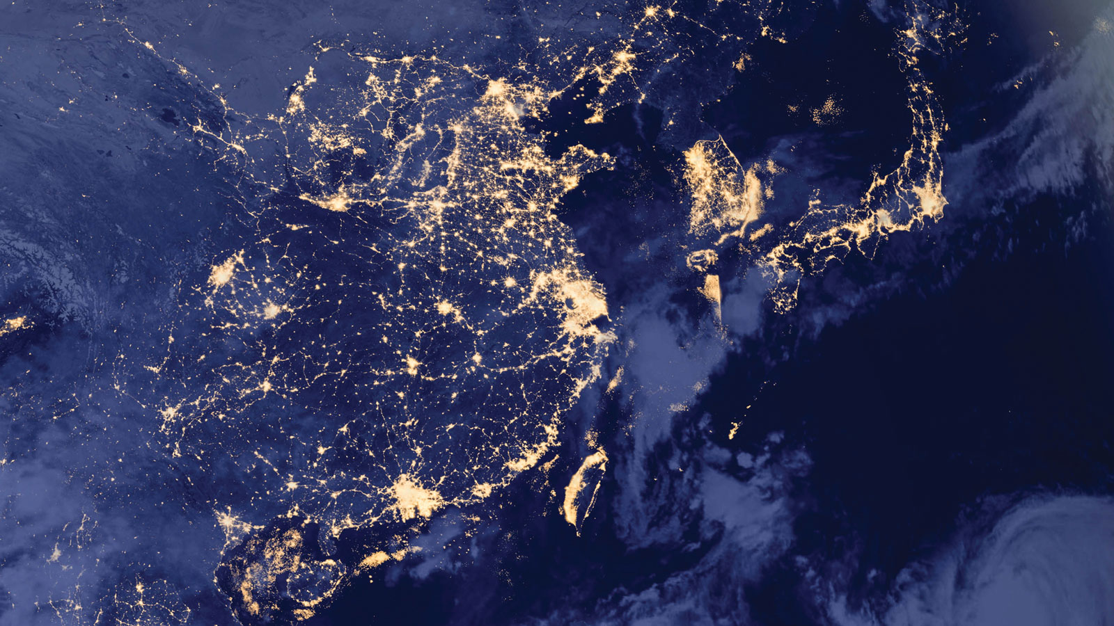
Scientists have been using satellite images of Earth at night—often referred to as “night lights”—to study human activity and natural events for almost 30 years. In the past decade, economists have followed suit, realizing that night lights can help gauge economic growth, map poverty, analyze inequality, and tackle numerous questions otherwise impossible to answer, especially in places where data are lacking. In fact, if aliens were ever to approach Earth from its dark side, they would already know some basics about the global economy long before reaching our atmosphere.

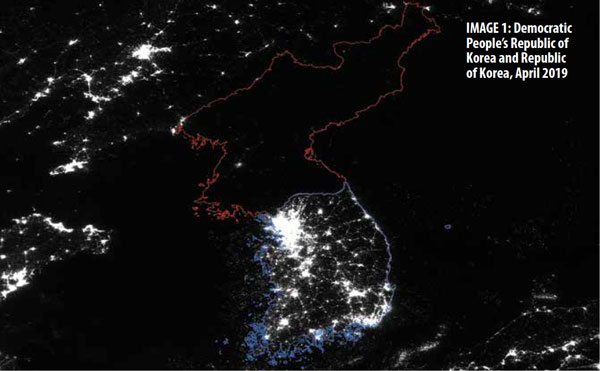
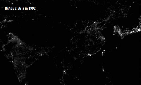
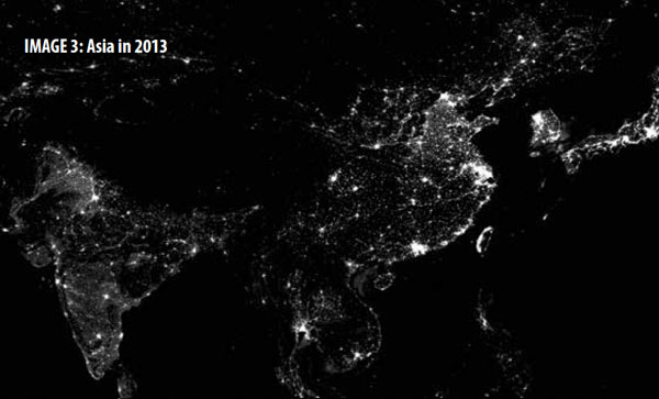
Human light shows, exotic seen from space, have recurrent themes. Take a look at the Korean peninsula and gasp at the stark difference between the north and the south (see Image 1). It is a contrast of darkness and brightness, of isolation and connectedness. Travel back in time and marvel at how fast China and India have been lighting up. It is a story of development and growth, openness and globalization.
How are night lights being used in economics? To understand this, we need to go back to the satellite images and gain some basic knowledge about their composition. Each pixel of a satellite image represents an area of less than one square kilometer on Earth. It is associated with a digital number that measures the brightness at night. The brighter the spot, the higher the number for that pixel. When these numbers are aggregated over all pixels in one country, it becomes an indicator that measures the activities of that country at night. When such an indicator is compared across countries and over time, it turns into a barometer of economic development and fluctuations.
Reflecting the changing economy
The relevance of night lights for economics is predicated on their strong correlation with economic activities, even though most of these occur during the day. Night lights broadly capture two aspects of the changing surface of an economy: expansion across space or, less often, spatial contraction. In growing economies, more areas are lit up over time and more pixels start to record light (see Images 2 and 3). By contrast, in regions mired in conflict, more patches of land become dark, and more pixels begin to lose light.


The other aspect is intensification. As rural areas urbanize, cities agglomerate, and infrastructure modernizes, the same night sky brightens, and more intense light is registered by satellite sensors.
The relationship between night lights and economic development, however, is not always straightforward. In my study with Johns Hopkins University’s Yingyao Hu, we compare night lights with GDP, the official and most commonly used measure of an economy’s performance. We find that rich countries are indeed brighter than less developed countries, but there is no lack of exceptions. On a per capita basis, Nordic countries have almost always been the brightest spots on Earth. On the other hand, Japan, despite being a rich country, looks scarcely brighter than Syria did before the Arab Spring, most likely because of its energy conservation habits and high population density.
When we account for country-specific characteristics of night lights, an interesting relationship emerges that reveals the remarkable transition from building physical capital to cultivating human capital that we observe as a country develops.
Countries at rudimentary stages of development focus mostly on infrastructure—building roads and bridges, constructing railroad stations and airports, and upgrading power grids and telecommunications, all of which emit light at night. As a result, the night sky appears increasingly bright in satellite images as the economy grows.
Advanced economies, on the other hand, power their economy through scientific and technological innovation, and the resulting productivity growth often has less to do with lights at night than the infrastructure that underpins this innovation. In fact, night lights grow only about half as fast as GDP in advanced economies.
What about countries whose official statistics are uncertain?
There is probably nowhere on Earth where good economic data are scarcer than in countries afflicted by conflict—yet these economies are among the places we need to track and understand the most. Statistics agencies in these countries may have long stopped functioning properly, but satellites are still witnessing economic activity.
It turns out that we can use night lights to reestimate the GDP of a conflict-stricken country, based on its similarities with other countries at various stages of development. When we do so, we find that the night-light-based GDP measure often points to faster economic deterioration during conflict than the official data show, but this measure also suggests a stronger bounce-back after the conflict ends. There is good reason to suspect that the ebb and flow of the informal economy plays a role in this postconflict environment.
The usefulness of night lights is not limited to a single indicator in economics. In fact, if we view each pixel of a night-light satellite image as a data point, an individual country such as the United States alone consists of hundreds of millions of data points. With more than 200 countries and regions in the world, the Earth’s land surface contains almost a billion data points.
That is a massive amount of data, and that count is only for one early satellite image with very coarse resolution. The number would grow exponentially with more frequent releases of satellite images of ever-finer resolution, which technology is making possible today. With hundreds of them already taken in the past and many more to be taken in the future, the images’ information is, to put it mildly, exploding. In that sense, night lights are no longer about the dark side of the Earth, they are about the digital side of the Earth.
Gaining new insights
With big data come new technologies to extract information and new insights
to gain into this world. It is not hard to imagine that advances in data
science, such as machine learning, can be used to analyze patterns and help
decision-making
with such data—many companies, such as DigitalGlobe and Orbital Insight, do
just that. As data science progresses, the granularity of this type of data
can be harnessed to study local effects, spatial spillovers, and economic
activities in the far reaches of Earth where the only reliable information
comes from hundreds of miles above.
And it is not just night lights. Countless data points hold stories we are only beginning to tell. Through the lens of satellite data, geospatial data, text data, and infinite other emerging sources of information, we will be able to gain new perspectives and form new ways of thinking about economics.
Suspended in a sunbeam, Earth is a delicate place in the vast expanse of cosmic darkness. But for our civilization, its dark side would have remained dark, as it was for billions of years. While night lights have been illuminating the Earth for more than a century, they have just started illuminating our understanding of it.
As we enter the age of big data, opportunities abound. We should seize this moment to leap forward, harnessing the power of big data to gain a keener understanding of the economy, guide smarter policies, and make this world a better and brighter place.
Opinions expressed in articles and other materials are those of the authors; they do not necessarily reflect IMF policy.


